
Dylan and I took a five day backpacking trip across the Pecos Wilderness in July, 2007. This is a description of our route and what we encountered along the way.
Finding a campsite each night was a little harder than I had thought it would be, mostly due to the Forest Service regulations about where it was okay to camp. All lake basins are closed to camping, and it's also prohibited to camp within 50 feet of a stream or trail. I've included a discussion of places to camp to help anybody else who might be planning the same trip.
Here's a map of our path:

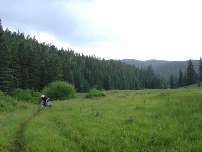
We took the Windsor Trail 254 past Spirit Lake to Windsor Creek. From there, we headed to Stewart Lake on the Skyline Trail 251. We had already hiked to Spirit Lake this way the week before, so there wasn't much new to see.
Stewart Lake is only a few miles from the Windsor Creek Trailhead. Because of this, there's a fairly well-used camping area just east of Stewart Lake if you continue along the Skyline Trail. We saw at least 5 fire rings scattered around. This is probably the easiest place to camp, but you'd have company on weekends.
The map above shows us going past Lake Katherine. We actually rerouted to the less-exposed route by Spirit Lake when we started hearing thunder.

We set out from Stewart Lake and headed north towards Horsethief Meadow. The map shows that it's pretty level, but in reality, it was a fair amount of up-and-down hiking (with a few short steep parts) between creeks. We reached Horsethief Meadow just in time for a hail storm. The trail followed the meadow for awhile, then eventually climbed another hill on its way to the next creek. Wet and tired, we stopped for the night shortly north of the junction with trail 256.
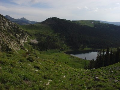
The gentle slopes of the Pecos Baldy offer several good camping spots less than a mile past the junction with 256. The trail gets much steeper after that, however, and there's not much flat ground again until you reach Pecos Baldy Lake. The area east of the lake is flat and probably perfect for camping.

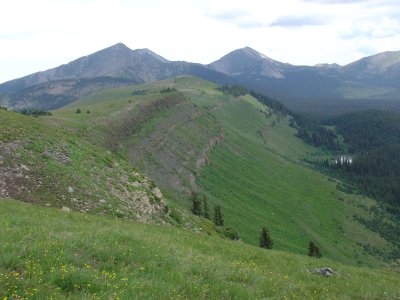
We spent an hour or so making it from our campsite to Pecos Baldy Lake, then decided to tackle Trailriders Wall. The wall is a high ridge between the Pecos Baldy and the Truchas Peaks. There are few trees, so the views in both directions are great. We were worried about thunderstorms, however, so we hiked as fast as we could over its 2.5-mile length. The sides of the wall are too steep to hike down for most of the way, so retreating into the trees wasn't an option. Luckily, we didn't hear any thunder until just after we had followed the trail off the wall back into the forest.
After the wall, the Skyline Trail stays mostly in the trees, so we stuck to it all the way to the Truchas Lakes. We camped just west of the junction with Trail 267 since there was a convenient stream. Just before the trail reaches the lake, there's a nice flat spot to camp to the east. If you continue past the lakes onto the Santa Barbara Divide, there are a few nice flat spots with stunning views to the South before the junction with trail 257.
The trail guide warned that the bighorn sheep were not afraid to enter camps and eat food. In reality, the sheep will eat many non-food items as well. One ate an unlit citronella coil while we were trying to shoo it away. If you're in this area of the Pecos, count on seeing these guys, and count on hiding anything that might be eaten.

We had originally intended to do this in one day, but at around 14 miles, it was too much. The hike to from the lakes to the Santa Barbara Divide was aided by a convenient trail not found on our maps. The official route goes east for about 2 miles from the lake across Chimayosos Peak, then cuts back west for at least a mile. This long switchback is visible all the way from Trailriders Wall. Our route cut north before the junction with trail 257 and probably saved us 2 miles of hiking.
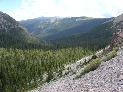
The descent into the river valley was dramatic. There were a few very decent campsites within a mile or two of the divide. Then, the trail started descending through switchbacks on the western side of the canyon, and there weren't any more campsites until it reached the river about 3 miles later.
We camped (too) close to the river in the meadows shortly after the river crossing. There would be plenty of campsites in the lush meadows, but the large number of grazing cows makes it difficult to find a clean spot. There is a large popular camping spot at the junction of the west and middle forks of the river, roughly 3 miles from the trailhead, and that's probably the last chance for camping on the whole route.
This was probably the least enjoyable part of the hike. We made it to the river on a Saturday, so there were people everywhere. Add to this the cow pie "minefield" and there was a lot not to like. Still, while the canyon was crowded, it was beautiful.
This was a great hike. The portions between Pecos Baldy Lake and the Santa Barbara Divide were the most impressive. This area of the Pecos is probably too remote for day hikers to reach.
Our favorite part was Trailriders Wall. Major peaks of the Pecos towered over us on two sides, and lush valleys lay below us in all other directions. On the wall itself, countless wildflowers bloomed. It was pretty amazing.
Last modified: Wed Jul 25 22:06:29 MDT 2007